

Earlier this week, we reported that Victoria could see snowfall at sea level this weekend.
However some parts of Vancouver Island could be in for an earlier start to snowfall season, according to Environment Canada.
The weather authority has issued alerts for Eastern and Inland Vancouver Island as meteorologists expect low elevation snowfall to start ramping up on Thursday evening.
See also: There is a 60% chance of snowfall in Victoria this weekend
“While there may be a few light flurries mixed with rain tonight, the first real opportunity for widespread low elevation snow is shaping up to be Thursday night,” reads the statement.
“A low tracking south along the BC coast will spread moisture across the BC South Coast beginning Thursday evening. With temperatures hovering near the freezing mark, a mix of rain or snow is possible across the region.”
Although the amount of snowfall will vary by region, higher elevations in Metro Vancouver and on Vancouver Island could potentially receive over 5 cm of accumulation.
Environment Canada expects the snowfall to turn back into rain on Friday morning, but the chance of flurries over the weekend holds strong for Victoria.
Here is the current forecast recorded at the Victoria-Gonzales weather station:
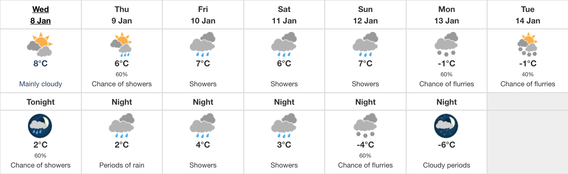
While The Weather Network does not include snow in its weekend forecast for the capital, they do expect temperatures to dip below freezing on Saturday and Sunday.
Vancouver-based meteorologist Tyler Hamilton says Vancouver Island residents can expect more snow in the near future, even after this weekend.
In a tweet, Hamilton predicts that the BC South Coast can expect the coldest temperatures the region has seen since 2008.
-15°C about 1500 metres off the deck is a good proxy for a significant arctic blast of air for S. Coast: early next week advertising potential to move towards the -20°C territory aloft – coldest temperatures since December 2008 likely. #BCcold pic.twitter.com/KaYFudr6re
— Tyler Hamilton (@50ShadesofVan) January 8, 2020