
The weather event we’ve been eyeing all week has begun, and after a day of sprinkling snow, Environment Canada has issued an official snowfall warning.
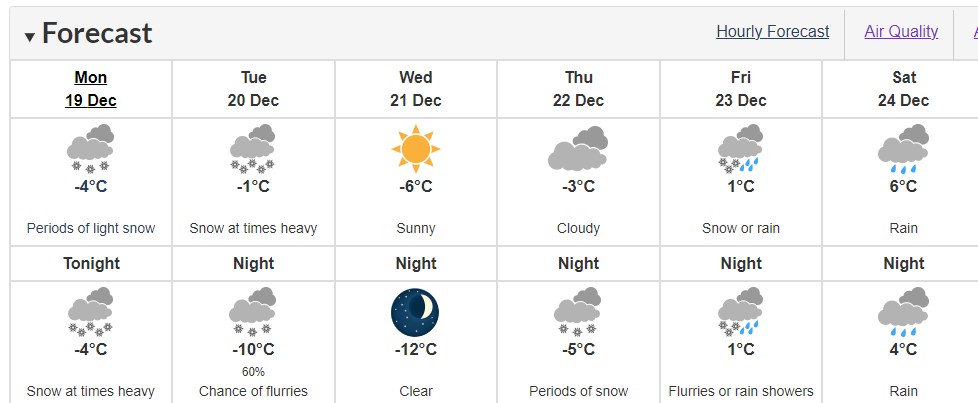
Most of the region was blanketed with light snow on Sunday and according to the latest warning, Victoria could see upwards of 20 cm of snow.
According to the weather agency, at least 10 to 15 cm of snow is expected to fall over southern Vancouver Island, however, Greater Victoria, the Malahat, Southern Gulf Islands, Lake Cowichan, Port Renfrew and Duncan to Fanny Bay could see upwards of 20 cm.
The following areas are impacted by this warning:
- Victoria
- Malahat Highway
- Southern Gulf Islands
- Lake Cowichan
- Port Renfrew
- East Vancouver Island from Duncan to Fanny Bay
Snow will taper off late Tuesday morning on Vancouver Island and Tuesday afternoon on the mainland side.
The dump of snow is coming from a low-pressure system that will land in Washington State, then sweep over the southern part of British Columbia starting late Monday night.
Temperatures will remain in the freezing zone for most of the week, with temperatures hovering at -10°C and 12 °C overnight on Tuesday and Wednesday.
As of this publication, things will begin warming up by Christmas Eve with and unfortunately doesn’t appear as though Victoria will get the white Christmas as Old Farmer’s Almanac had predicted earlier this month.
While authorities are asking motorists to avoid driving during this time unless required, Victoria Buzz has compiled a list of road cameras for you to check the latest conditions before heading out.
Stay safe and have fun!