Hey there, time travelers and history buffs!
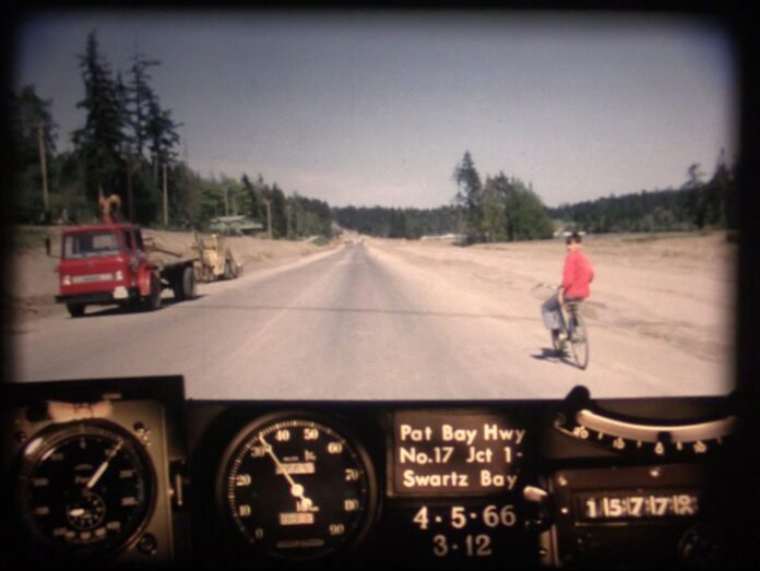
Get ready for a delightful ride as we take you on a trip back to the spring of 1966 when Victoria was a tad different from what you know today.
Buckle up as we embark on this nostalgia-filled journey down the memory lane of Vancouver Island’s Highway 17, also known as the Patricia Bay Highway—and Pat Bay Highway.
Before we dive into our time machine and hit the gas, let’s give you a bit of background on the Pat Bay Highway.
This iconic road actually consists of two separate segments, one on Vancouver Island, and another on the Lower Mainland, connected by a ferry ride.
Our focus today is the picturesque island section that stretches between Victoria and the Swartz Bay Ferry Terminal, just north of Sidney on the charming Saanich Peninsula.
As we kick off our journey through this vintage video, you’ll notice some fascinating glimpses of a Victoria that was still finding its modern groove:
0:05 – The starting point of Highway 17 in 1966 was on Douglas Street near Carey Road. Before it was officially numbered, this stretch was known as East Saanich Road.
0:10 – 0:16 – In those days, McKenzie Avenue was a quaint rural street with no connection to Highway 1. Traffic flowed alongside the serene Swan Lake and Christmas Hill area. If you look closely, you might spot school children strolling along the highway, perhaps on their way to the nearby Pacific Christian School.
0:32 – Quadra Street merges with the highway on the right. The Quadra Street overpass that connects to the bustling Royal Oak shopping area hadn’t been built yet, and it wouldn’t appear until the 1970s.
0:36 – You’ll come across the junction of Highway 17 and 17A, also known as West Saanich Road. This route led to the renowned Butchart Gardens and the ferry across the Saanich Inlet to Mill Bay. Highway 17A, which was formally designated in 1962 but later lost its status in 2000, was a popular alternate route through the peninsula.
0:45-0:53 – Before the divided highway you know today, Highway 17 passed right in front of Beaver Lake Park, following what is now called Elk Lake Drive.
1:00 – Keep an eye out for Haliburton Road on your right.
1:16 – The Sayward Road Intersection awaits just ahead.
1:40 – As you approach Keating Cross Road, notice the landscape, which was far less developed in ’66.
1:42 – East Saanich Road veers off to the left, leading to more scenic adventures.
1:48 – Island View Road intersects, offering access to more island delights.
2:07 – Keep cruising to Mt. Newton Cross Road and beyond.
2:40 – McTavish Road joins the party.
2:58 – We’re nearing our destination, Sidney, as we pass through the Beacon Avenue Intersection.
3:07-3:37 – Witness some road widening work as we approach the Swartz Bay Ferry Terminal, a vital link to the mainland.
3:27 – Wain Road intersection marks the end of our journey, as we prepare to board the ferry.
In just a few short minutes, this video takes us on a captivating journey through time, showcasing the evolution of Victoria’s landscape and the Patricia Bay Highway.
It’s a testament to how much has changed since 1966, yet also a reminder of the enduring beauty of this picturesque region. So, next time you find yourself cruising down Highway 17, take a moment to appreciate the history that lies beneath the asphalt.
And with that, we bid farewell to our time-traveling adventure on the Patricia Bay Highway. Until next time, keep your eyes peeled for more glimpses into the past because, after all, history has a way of making every road trip just a little more fascinating.


